Blog Archives
Iridescence near the ground
Iridescence is caused by light diffraction of water droplets of clouds. The wave nature of light forms new waves at the small drops. In certain directions they interfere and can amplify each other. It is important that the droplets are very small, not considerably larger than the wavelength of light (micrometre range). Such drops occur mainly in medium-high and high clouds. The edges of lenticular clouds iridesce most frequently.
But in very rare cases iridescence emerges below the sun in near-surface layers of fog. Two cases have been seen in the last time.
On 05th December 2015 Claudia Hinz observed cold fog from the Bohemian valley of river Eger accumulating at the crest of the Ore Mountains (German: Erzgebirge; Czech: Krušné hory). As in the afternoon the sun was above the cloud wall, the clouds edge iridescend first and later the complete wall of clouds appeared in slight pastel colours. Iridescence on the frequent Bohemian fog couldn’t be observed previously.

On 09th March 2016 Richard Löwenherz observed slight iridescent shallow fog. It was a windless and sunny late afternoon in the Swedish Jämtland. An anticyclone had establish and caused a gradually clearing sky. In a deep depression originated shallow fog already before sunset, as well as above the frozen Hällsjön at Kaxås in the north of Storsjön. But this scene was unusual. As the ceiling of the flat layer of fog was slight iridescent between 17:10 to 17:15 CET (directly below the sun) it was a real surprise. At this time the air temperature was a little bit below the freezing point. Perhaps in the valleys, where the fog was formed, the temperature decreased below -5°C.
It is worth mentioning, that there was striking iridescence in stratus and stratocumulus fractus since the morning.

Authors: Claudia Hinz, Richard Löwenherz
“Rainbow”-contrail

Iridescence contrail. Photo: Ron Smith
Contrails are a result of water vapour, produced as a product of combustion, being ejected from the aircraft engines (→ article)
When a contrail forms near the sun, it’s possible to see a rather beautiful ‘rainbow effect’, as in this example. Such iridescent clouds are a diffraction phenomenon caused by small water droplets or small ice crystals individually scattering light. The aerodynamic contrail formed by the reduction of pressure in the air as it moves over the wing. When the pressure of a gas falls, then its temperature also falls (the same principle as is used by your refrigerator). The reduced temperature causes small drops of water to condense, which then may freeze. The (frozen) drops get larger as more water condenses on them. The iridescent colours are sunlight diffracted by millions of water droplets condensed by the airflow over the wings. The droplets all have similar life histories and therefore similar sizes, ideal conditions for iridescence.
The photograph was taken by Ron Smith at around 1300 local on 18 July 2015 at Henstridge, Somerset, UK. The aircraft was flying from East to West and, when first seen, was only producing an intermittent contrail. The iridescent contrail appeared as the aircraft approached a cloud layer just below its flight altitude.
One of nature’s works of art!
Authors: Ron Smith, Somerset, UK and Claudia Hinz, Germany
Iridescent pileus cloud

Iridescent pileus cloud · Photo: Gabriele Schröder
Sometimes it occurs that small cloud cap forms above a cumulus or cumulonimbus cloud. These caps, wich are similate to a veil, are called pileus (cap) and indicate that the air above the cumulus cloud is very humid. The humidity is near the saturation point, so that a cloud can form. If this cloud cap is near the sun and the glare of the sun is in an ideal case reduced by the cumulus cloud covering the sun, iridescent colours appear in the cloud cap.
The intense colour of a pileus cloud indicates that the water droplets in the cloud are very small and of a uniform size.
Such an iridescent pileus cloud could be observed by Gabriele Schröder on June 6, 2015, at 6.50 P.m. in Schneeberg in the Erz Mountains. The phenomenon appeared in three different parts of the cloud within 10 minutes. Especially interesting is above all the shadow in this picture, which was cast by the lower cumulus cloud and projected upon the clouds. Faint rays can also be seen behind the cloud, indicating that also the surrounding air is very humid.
Cloud Iridescence along the Alps and in Hungary

On January 10, 2015, unusually bright and colourful iridescent clouds were observed along the Alps between Switzerland and Hungary. To display the huge area in which the observations were made, Kevin Förster plotted all known observations into the satellite image taken at 12 noon that day.

The cloud iridescence was observed in 7 countries (Switzerland, Liechtenstein, Austria, Germany, Italy (Southern Tyrol), Slowakia and Hungary). The westernmost observation point is Fribourg in Switzerland, the easternmost one is Tápiószolos in Hungary. This means that the iridescent clouds were observed along a distance of 965 kilometres and in an area measuring about 122,500 square kilometres, which ist about a third of the area of Germany. There is no case of a similarly distinctive iridence known so far.
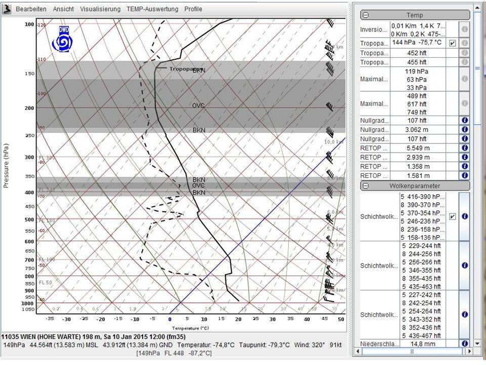
Many observers reported iridescence stretching up to large angles from the sun and a great similarity to nacreous clouds. These form above northern latitudes at very low stratospheric temperatures beneath -80°C in the ozone layer. The iridescent clouds were visible until 20 minutes after sunset, followed after an intense afterglow on clouds which still received sunlight up to 45 minutes after sunset. At some places eye-catching crepuscular rays were also observed. The 30 hPa-Chart, however, shows that it was much too warm for polar stratospheric clouds to form.
Nevertheless the cloud layer must have formed at higher altitudes than normal. One observer reportet that all airplanes flew beneath the clouds, and also many pictures show contrails below the cloud layer. So the clouds probably formed at more than 12,000 metres above ground.
Discussions about the weather situation in our forum and measurements by the Austrian weather service (Central Institution for Meteorology and Geodynamics ZAMG) showed several peculiarities of the situation: Strong foehn winds caused gravity waves which peaking at about 14,000 metres above ground. This was the level of the tropopause, which was unusually high for these latitudes that day. And it also was unusually cold, as a radiosonde launched in Vienna measured a temperature of -75.7°C. The highest of the multilayered foehn clouds formed along the tropopause. Due to their high altitude, their droplets were of the optimal size to cause iridescence. Unfortunately, it can not be clarified if there also formed small ice crystals like in nacreous clouds because strong vertical movements may impede the freezing of the droplets.
Video from Thomas Klein, Miesbach, Southern Germany
Thanks to all who put their pictures at our disposal and helped us with data, special knowledge and hints to clarify the reason for this phenomenon. The discussion can be found, together with a lot of photographs and some time lapse videos in the forum of the Arbeitskreis Meteore e.V.
Authors: Claudia Hinz and Kevin Förster
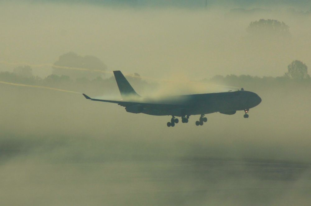
Wake vortices caused by planes
When air humidity is high, sometimes wake vortices can be observed on the wings of a plane. These are an accessory phenomenon of the ascending force, which needs a certain underpressure to be effective. This underpressure makes the air flow from beneath the wing to its surface for pressurization. As in these vortices there is an area of especially low pressure, the air cools down adiabatically here, often reaching temperatures below the dew point. This makes the water vapour in the air condensate to steam or fog, making the wakes visible.

In the morning of October 8, 2012, Renate Possiel could take a photograph of this phenomenon from the control tower of Munich airport. That day there were wafts of mist with different ranges of sight on the runways. More photographs: 1–2–3
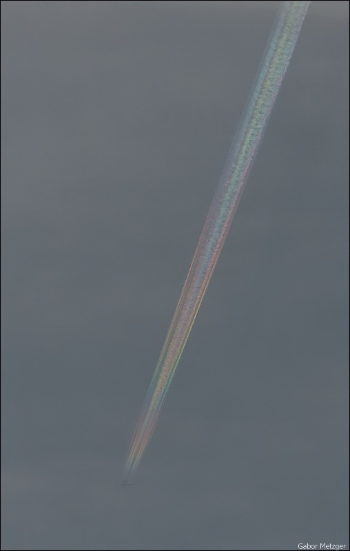
Another reason for wake vortices to form is the downward acceleration of the air along the wings when the plane is ascending. At low temperatures and high humidity, also here visible condensation can occur. When a plane passes near the sun, sometimes an iridescence of the wakes can be observed, as showed in this photograph taken by Gabor Metzger.

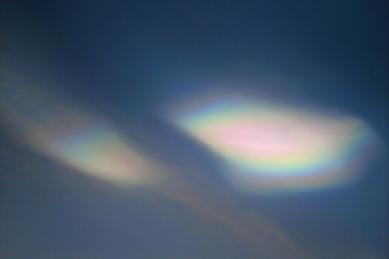
More often iridescence can be observed on contrails, especially when they are very “young”. Also these photographs (1–2–3) taken by Gabor Metzger.
Another articles to this topic:
Norway iridescent foehn clouds

On February 6, 2011, Dirk Steinborn observed these beautiful iridescent foehn clouds in Favang (about 1-hour-drive north of Lillehammer, Norway). The photographs were taken between 14 and 15 hours CET. The observer supposes: “Probably there weren´t any mother-of-pearl clouds. It is cirrus, but also some medium level clouds had a reddish colour.”
Ice particle iridescence?

Normally, iridescence shows rather faint colours which can only be seen by covering the sun. On December 6, 2010, however, iridescence was visible in such a brightness and colourfulness in high level clouds that at first sight it rather looked like halo fragments than like iridescence. (1–2–3)
Manfred Nehonsky also observed extremely bright iridescence on high level foehn clouds over Upper Austria the same day. This iridescence looked like bright mother-of-pearl-clouds.
Another observation made the same day, but by mistake entitled as a halo, can be found here.
I think this is iridescence on globular ice particles as Paul J. Neiman and Joseph A. Shaw suggested in their article “Coronas and Iridescence in Mountain Wave Clouds Over Northeastern Colorado“.
Author: Claudia Hinz, Germany
Iridescent Fireworks Smoke

Like everywhere around the world, New Years Day was also welcomed with fireworks around Mt. Wendelstein. It is always a special highlight to watch the fireworks from the top of the mountain at 1838 meters above sea level. In the Leitzach Valley, about 1000 meters lower, there was a fireworks display.
Even when watching it with the naked eye, the smoke and fog of the fireworks seemed to show iridescent colours. The photographs (photo) show the iridescence more obviously. It was probably caused by the condensation nuclei from the fireworks smoke, on which small droplets condensated. As short time before an area of precipitation had passed, air humidity was still very high.
Additionally, the fireworks caused a thin layer of fog over almost the whole alpine foothills area (photo), and the big city of Munich with more than a million inhabitants, was covered by a thick layer of clouds (photo).
Similar things were reported by other observers. In Bochum, Peter Krämer observed that light graupel turned into snow during the fireworks, leaving about a centimetre of snow. On the weather radar it could be seen that a precipitation area formed right over the Ruhr area just after midnight.
Two years ago, thin fog with visibilities around 300 meters thickended after the New Years Fireworks, forming a dense layer of fog with visibilities which were less than 10 meters in some places.
Posted by Claudia Hinz
Aircraft Iridescence

While taking wildlife pictures in a nature reserve close to the Vienna, Austria, airport, Franz Kerschbaum noticed this 747 jet aircraft in a landing approach with a huge condensation cloud behind its wings. As it moved closer to the runway, he was evidently at just the right position for this shocking but beautiful artificial iridescent cloud to come into view. Iridescence and coronas are diffraction phenomena. The pastel or metallic colors result from deflection of sunlight about minute water droplets.
Photo details: Canon EOS 30D camera, 100-400 mm/4.5-5.6L lens at 400 mm and f/8.0
Extremely bright iridiscence in Spain

On Saturday, February 10, 2007, Ramón Baylina shot these photographs of incredibly bright and colouful iridescent clouds at the Port of Tarragona (Spain). The pictures were taken at about 5 pm with a 200-mm-zoom lens.”
More pictures are here
