Category Archives: self-luminously phenomena
Lunar odd radius display in diamond dust

On four out of last five winters Tapio Koski has photographed lunar diamond dust odd radius halos in the Rovaniemi area. These one-per-winter occurrences are almost solely responsible for lunar diamond dust odd radius displays photographed in Finland during those years. This winter we wanted take part in the tradition. Yet despite numerous odd radius displays we had harvested in the beam, those by the moon – or sun for that matter – were simply not on the offing.
Except on the night of 20/21 January, which was the month’s last diamond dust night in Rovaniemi. During the day, when driving in the city, we paid attention to Fairbanksian amber, a beautiful yellow glow in the sun direction which can be seen in cold weather and with which we became familiar on the succesful halo expedition to Fairbanks in January 1996. This gave us an omen of foreboding that a night of big odd radii diamond dust was finally on the cards for Rovaniemi. Weather forecast was with us too, as the temperature was expected to drop to -33° C – the magic number that Walt Tape has given as being in the center of the temperature range favorable for odd radii.
The display appeared as some thin water cloud that had momentarily overtaken the sky cleared away. The first halo visible was upper 23° plate arc, many others soon followed the suit. In the beam only a crappy plate dominated display was visible – the pyramid stuff was higher up.


Authors: Jarmo Moilanen, Marko Riikonen, Finland
Red sprites over a convective storm system over the North Sea on July 2nd/3rd, 2015

Sprites · Photo: Laura C. Kranich
Still today we have atmospheric phenomena many people have never heard of, know little about or have at least never seen themselves. For me one phenomenon I had never seen until recently are the so-called red sprites. Red sprites are a high atmosphere light phenomenon (also “transient luminous event” or TLE) related to thunderstorms and extend over altitudes between 40 and 100km above ground. They can have various forms, sometimes like carrots or tendrils, often reticulate, sometimes rather bushy. It has been shown that positive lightning is at least correlated to the occurrence of red sprites, probably triggering them under certain conditions as sprites mostly occur a few to several milliseconds after CG+ (cloud-to-ground positive) lightning. Negative cloud-to-ground lightning (CG-) can rarely cause sprites, approximately 99% of sprites are related to CG+-flashes. Positive lightning is a tropospheric type of lightning where an electrical discharge from the positively charged anvil (top) of a thunderstorm to the ground takes place whereas much more common negative lightning originates in the lower part of cumulonimbus clouds. A discharge from the top of a thunderstorm to the ground requires an enormous amount of charge (hundreds or thousands of a Coulomb) so they only make out a small percentage (about 5-10%) of all lightning in thunderstorms and have been found to be more likely to occur in longer-lived dissipating thunderstorms and winter storms (maybe because the tropopause is a few kilometers lower during winter, hence less charge is required for a discharge from the top of a thunderstorm to the ground). The conditions above a thunderstorm, in the stratosphere, mesosphere and ionosphere are also important for the formation of sprites. Yet the exact processes in and around thunderstorms that lead to the occurrence of sprites are still not fully understood. What is certain is that most thunderstorms do never cause sprites. From satellite observations a global sprite occurrence rate of approximately 1 per minute has been derived whereas the tropospheric flash rate is about 3000 times higher: 44 per second on average. Most sprites appear over Mesoscale Convective Systems (MCS) with a cloud top area of more than 100.000km² while above super-cells or air-mass convective storms rarely any sprites are observed, though super-cells can trigger other TLE like e.g. blue jets.
During the night from July 2nd to 3rd, 2015, I was out in the fields near Felmerholz a few kilometers outside of Kiel, Schleswig-Holstein, actually hoping for some noctilucent clouds. These days they can often be seen here throughout the whole night as the sun never goes below approximately -13° altitude. Fortunately they did not appear which seems rather absurd to say. But instead of focusing on the northern horizon I began to center my attention on the thunderstorms at the convergence line moving from the Netherlands through the North Sea towards Denmark and the extreme northwestern Germany at that time. It is not clear if this system can be characterized as MCS, though its sheer size on satellite images allows of that suggestion reaching from the northerly Netherlands and western Germany to northern Denmark. For me it was visible over the northwestern horizon and steadily producing visible tropospheric lightning about 150-200km away.

I decided to try to catch some sprites which I have been trying for years when the conditions seemed good. I was pretty sure it would be impossible to catch them as the moon was shining practically at its fullest and midnight twilight was the other reason I did not really believe in this possibility. Though I had a hope. So to maximize the chances of capturing sprites, which I assumed to be a very faint phenomenon, I thought it would be best to reduce the exposure time and increase aperture and ISO setting to compromise between a short light integration time and image quality. So I started continuously capturing images of the distant thunderstorms at 16mm, 3.2s, f/2.8, ISO3200 on a Canon 7D (APSC) for around two and a half hours. After about 30 minutes I recognized the first, my very first sprite on a picture struggling to believe in what I saw. Not only since there was a sprite visible on the image high above the thunderstorm but I was also puzzled about its brightness and size. I continued to shoot for another two hours, the whole observation period was between 22:25 UT and 0:50 UT. As I continued I found another three sprites on my images. When I later analyzed the raw images on my computer I found three more sprites on the images which were rather small and faint compared to the others seen before.
The first (faint) sprite I captured occurred at 22:37 UT, which is just 12 minutes after I started. The next ones were at 23:03 (bright), 23:18 (bright), 23:26 (bright), 23:29 (faint), 23:35 (bright) and 23:39 UT (faint). True midnight, when the sun is lowest, was at 23:23 UT with a sun altitude of a bit above -13°, so it was barely astronomic twilight. Of course there are some gaps between all images (mostly approx. 0.2s, but sometimes several seconds up to a few minutes due to image revision) so that it is absolutely possible that even more sprites actually did occur. I could not see a single one with the naked eye, though I don’t want to say it wouldn’t have been possible. At least the images suggest, it would have been possible to see and my eyes were not too focused on what happened in the sky.


Remarkably all sprites appeared over the northern part of the squall line, which was approximately 200km away from me. There’s one other observation of the very sprite at 23:03 UT from central Mecklenburg-Vorpommern, which suggests that even much greater distances from a thunderstorm of several hundred kilometers may allow suitable conditions for observing sprites but also smaller distances of just around 100km might be suitable. After about 0 UT (2 am CEST), when no more sprites appeared over the northern part, I tried to capture some over the more southern part, but within an hour, no more sprites could be captured by the camera though the tropospheric lightning activity remained high. I did not change the camera settings during the whole image recording, so if they had occurred they would likely be visible in the images. Of course it is still possible I missed some due to the camera reaction time. But from my observations, I want to make the educated guess that there must have been a difference between the northern and the southern part of the squall line, which certainly was not the frequency of the visible tropospheric lightning but probably the fact that the northern part was indeed dissipating with a slowly decreasing frequency of discharges.
During these two and a half hours I took more than 2000 images to get at least seven sprites. If the sky would have been darker I could have used longer exposures and thus had to take less images but I would say it was definitively worth it.
Literature:
Christian, Hugh J. and McCook, Melanie A. “A Lightning Primer – Characteristics of a Storm” @ NASA. http://thunder.nsstc.nasa.gov/primer/primer2.html
“Charge transfer and in-cloud structure of large-charge-moment positive lightning strokes in a mesoscale convective system”, Blakeslee et al., 2009, doi:10.1029/2009GL038880
Lang, T. J., W. A. Lyons, S. A. Rutledge, J. D. Meyer, D. R. MacGorman, and S. A. Cummer (2010), Transient luminous events above two mesoscale convective systems: Storm structure and evolution, J. Geophys. Res., 115, A00E22, doi:10.1029/2009JA014500.
Victor P. Pasko, Yoav Yair, Cheng-Ling Kuo. (2012) Lightning Related Transient Luminous Events at High Altitude in the Earth’s Atmosphere: Phenomenology, Mechanisms and Effects. Space Science Reviews 168:1-4, 475-516.
Author: Laura C. Kranich, Kiel, Germany
Another St. Elmo´s Fire on Mt. Hoher Sonnblick

For the third time, the meteorological observatory on Mt. Hoher Sonnblick (3106m) in the Hohe Tauern mountains registrated St.Elmo´s Fire on its webcams (2–3). But contrary to the two preceding cases (1–2), this time St. Elmo´s Fire occurred during a thunderstorm, the nearest lightnings of which were about 600 metres away. While St. Elmo´s Fire appeared, the intensity of the electric field increased from -3000 up to +8000 V/m (unfortunately no diagram available). At the same time, snowfall was recorded at temperatures of -2°C.
The webcam which recorded St. Elmo´s Fire is located on a ridge between Mt. Goldbergspitze and Mt. Roter Mann at about 2970 metres above sea level looking northeast. On the right Mt. Goldbergspitze can be seen, and in the centre of the picture there is the Kleinfleißkees wit Mt. Hoher Sonnblick. The highest mountain on the left is Mt. Hocharn (3254m). The camera is part of a glaciological research programme around the Sonnblick-observatory. Its purpose is to provide data about the snow cover of the Kleinfleißkees and is operated by the ZAMG (Zentralanstalt für Meteorologie und Geodynamik – Central Institution for Meteorology and Geodynamics).
Extremely St. Elmo´s Fire on Mt. Hoher Sonnblick

Last night the webcam of foto-webcam.eu registered on Mt. Hoher Sonnblick (3106m, Hohe Tauern, Austria) stunningly St. Elmo’s fire again. And as in the first case, the small purple flames were not caused by thunderstorms, but by a combination of heavy snowfall and wind.
The diagrams show the measured field strength in conjunction with the fallen precipitation which is completely fallen as snow.


A time-lapse recordings of different webcam shows the unusual length of the St. Elmo´s Fire.
Thanks to Hermann Scheer from the Meteorological Observatory Hoher Sonnblick, Austria for the interesting material.
Reconstruction of height and position of the green airglow from July 15th, 2012

It was an ironic situation when during the night from 14th to 15th of July 2012 (at a weekend) a high number of observers and photographers were looking for a predicted aurora borealis and instead were confronted with a remarkable outburst of structured (or banded) green airglow. This phenomenon is well known and explored by professional geo-scientists but seemed to have slipped the attention of most amateur observers, including myself, up to then. Though it first seemed likely that the geomagnetic storm may have somehow triggered this event, later observations (e.g. July 23rd, 2012: http://www.polarlichter.info/airglow.htm) indicated that the traditional excitation mechanism (UV and X-Ray radiation from the sun) is capable of producing intense green airglow without the need for a geomagnetic anomaly.
Due to the fascination I felt during my own observation, I got interested in using the many available photographs from the July 14th/15th night for a height and position reconstruction. However, as I later found out from literature, the airglow height of 87-95 km (i.e. a quite thin layer, comparable to the NLC layer around 83 km) is already well established by professional measurements. It is remarkable that this value can in fact be reproduced by comparing amateur photographs from various locations in Germany by an un-biased analysis, which I want to present here.
The first task to do was to contact other observes via the well-known communication boards about atmospheric optics to gather suitable photographic material. Of course I had my own images at hand and intended to use them for this process, so I already had a list of time slots to find synchronous counterparts for. Even though I could find several pictures taken within a tolerance of < 1 minute with respect to my own photos, I had to drop most of them since a coarse analysis of the viewing directions yielded no overlapping fields of view. But through discussing my idea with several other photographers, I was able to identify other matching pairs independent from my own material. Finally, I ended up with two data sets (image pairs), 1 and 2, to work with:
1a) Frank and Sabine Wächter: July 15th, 00:55 CEST, 51° 12’ N, 13° 35’ E, 189 m above sea level (Meißen, Saxonia): https://dl.dropbox.com/u/8849406/Forum/AirglowBlog/1a.jpg
1b) Jens Hackmann: July 15th, 00:55 CEST, 49° 29’ N, 9° 55’ E, 333 m above sea level (Weikersheim, Baden-Württemberg): https://dl.dropbox.com/u/8849406/Forum/AirglowBlog/1b.jpg
2a) Franz Peter Pauzenberger: July 15th, 02:02 CEST, 49° 00’ N, 11° 30’ E, 518 m above sea level (Beilngries, Bavaria): https://dl.dropbox.com/u/8849406/Forum/AirglowBlog/2a.jpg
2b) Alexander Haußmann: July 15th, 02:01 CEST, 51° 32’ N, 13° 58’ E, 110 m above sea level (Senftenberg, Brandenburg): https://dl.dropbox.com/u/8849406/Forum/AirglowBlog/2b.jpg
For a detailed analysis, it is necessary to calibrate these photos, which means to precisely assign values for azimuth and elevation to each pixel. If the projection characteristics of the photographic lens are known, the positions of two stars in each picture are sufficient input for this purpose. However, the simple assumption of an ideal gnomonic (rectilinear) or equal-area projection (for ordinary and fisheye lenses, respectively) drastically limits the accuracy of the results. To overcome this, the projection characteristics for all four lenses were reconstructed by measuring the pixel distances of approximately 15 stars from the image center and compare these with the angular distance from the optical axis for each image.
After this calibration and assignment, longitude and latitude positions for each pixel can be calculated, allowing the projection of the photo onto a map if a certain height of the airglow layer is assumed. This method already proved to be very useful for the reconstruction of NLC positions (http://www.meteoros.de/php/viewtopic.php?t=8451). Since the goal is here to determine the layer height, this parameter is varied until the corresponding structures in both reconstructions of an image pair give the best fit. Indeed it was possible to find consistent height values for both data sets, 92 km for pair 1 (https://dl.dropbox.com/u/8849406/Forum/AirglowBlog/1.gif) and 93 km for pair 2 (https://dl.dropbox.com/u/8849406/Forum/AirglowBlog/2.gif). Here the traditional blink comparison technique was applied in a modern form using gif animations. It is fascinating to see how the airglow structures that look completely different in the original two photos of each pair coincide in the reconstruction on the map. Evidently, all non-airglow structures such as trees, background light, clouds, photographic violet aurora etc. have to be ignored in the reconstruction. It should be noted that more complex approaches (http://www.opticsinfobase.org/ao/abstract.cfm?uri=ao-51-7-963) are recently established in the professional field, allowing even to resolve finer structures within the thickness of the airglow layer.
Furthermore, these reconstructions show an undistorted view on the band structure of the green airglow layer. As already expected from the perspective view of the original photos, these bands are roughly aligned in the direction from West to East. Using the consistent height information obtained from the image pair comparisons, it is moreover justified to project a whole picture series from a single observation site onto the map in order gain insight in the airglow band dynamics. For this purpose I used a time lapse series that I took from July 14th, 23.16 CEST to July 15th, 01.20 MESZ at the Senftenberger See (51° 29’ N, 14° 01’ E), starting in the evening dawn and originally intended to capture the predicted aurora borealis (https://dl.dropbox.com/u/8849406/Forum/AirglowBlog/3.avi). Due to the weak contrast of the airglow at this stage, strong image processing is needed to separate the bands from the background. Though this finally results in a rather poor signal to noise ratio, it can clearly be seen that the airglow bands move in northward direction (https://dl.dropbox.com/u/8849406/Forum/AirglowBlog/4.avi), illustrating the recombination and/or matter transport dynamics in the mesopause region.
Author: Alexander Haussmann
St. Elmo´s Fire on Mt. Hoher Sonnblick

On November 28, the webcam of the Meteorological Observatory on the 3106 metres high Mt. Hoher Sonnblick in the Hohe Tauern Mountains in Austria could catch this unbelievable St. Elmo´s Fire. This photographic webcam, a Canon EOS 1100D, was installed by radio hams and takes one picture every 10 minutes.
Weather observer Hermann Scheer describes the meteorological situation as follows: “The day the pictures were taken ist was snowing, and there was a stormy southwesterly wind with wind speeds around 60 kph. There was no thunderstorm near. I did not notice any discharges, but I could clearly hear the crackling noise on the tower outside, which is always a sign that there is a certain voltage applied. When I went to the platform with my camera the first time, I could not catch St. Elmo´s Fire quite clearly and did not really notice how strong it was. Later, during the second photo shooting, the camera on the tripod began to sparkle, and I also noticed the tension in my short hair. Then I saw St.Elmo´s Fire on the suntracker. The interesting phenomenon lasted for about one hour.”
A high field strength under conditions with falling snow and strong wind is not very rare, as these example diagrams from a day with similar weather conditions show (1–2). When there is enough tension generated by wind friction and high humidity, an electric current begins to flow between the charged air and the point of the instrument. The air becomes ionized generating a flickering, pale blue light that looks like a flame. St. Elmo´s Fire is probably reported so rarely because only very few people look for it on mountain tops under such weather conditions, and during thunderstorms there are no people there.
But even if St. Elmo´s Fire is very beautiful to see, it is in any case a warning. If you see St. Elmo´s Fire near, it is probably a hint that a discharge is imminent. So, if you see it, you should look for shelter immediately.
Airglow – When a „green aurora“ turns into an even rarer phenomenon

During the night from July 14 to July 15, 2012, Tilo Schroth could observe and photograph in northern Saxony, Germany this rare phenomenon: “Chasing aurorae from northern Saxony is full of surprises. You are burning the midnight oil in the middle of nowhere during nights which potentially might bring a touch of aurora, pressing the release from time to time, controlling the monitor display, and then looking up to the sky again. A shooting star here, a small satellite there…there is a lot to see during those nights. The same was it during the night between July 14 and July 15, when the solar wind was about to hit earth directly. We were three persons on the Liebschützberg range (except from some couples in love). We were just about to call it a day when a slowly increasing green loom appeared on our monitors. At that moment I still was connected to the Meteoros-forum, but a short while later the storage battery of my mobile phone showed empty.
My two friends and me on the hill were sure that this was a green aurora. So we were very excited. We were not connected to the forum any more, where somebody already had talked of “airglow”. Nevertheless, we were not disappointed when learning that our guess was wrong the next day.
What we saw – and could not really interpret – was really airglow. Appearing as a grey veil to the naked eye, our reflex cameras reveiled its real structures.”
“Airglow” is the name for a faint, lamellar glowing of the night sky which is induced by electromagnetic radiation. In normal cases, this diffuse glooming can hardly be perceived, but its brightness can be influenced by strong ionospherical activities. So airglow could not only in this case be seen in connection with solar wind and aurorae. The latter were visible over Germany also in this night, but just very faintly.
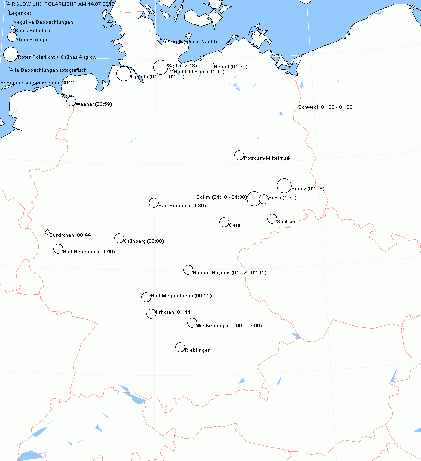
An interesting fact is the far southward extension of the airglow shown on a map made by Stefan Krause, which shows all observations. This is probably due to the fact that in Northern Europe it does not really get dark at this season. So parts of the atmosphere might get some sunlight which may intensify the airglow.
In the Meteoros-forum are more pictures from this rare phenomenon.
Heavy Thunderstorm Sprites above Czech Republic


On May 26, 2011, Martin Popek filmed sprites above an area with heavy thunderstorms preceding a cold front in Nydek (Eastern part of Czech Republic) with its video camera (Watec 902h2 ultimate + lens 8/1,3). The radar map (1–2) shows the position of the observer and the approaching thunderstorm front.
St. Elmo’s fire in Switzerland
On Nov/14/2007 between 18:00 and 19:00 CET St. Elmo’s fire appeared on a tower at the summit of Mt. Gäbris in Switzerland. The phenomenon was captured with a high sensitive video camera operated by Mark Vornhusen of Meteomedia, a private weather company.

The St. Elmo’s fire developed during a snow thunderstorm. Only one lightning strike occurred during this storm. The strike is visible on the webcam images at 18:55 CET as a sudden flare of the image and was heard by the author, who lives 2km away from the summit. The lightning strike was not close to the tower, because the flare was not very bright. The cameras operate with a special software that is able to capture all bright objects on the night sky, even if the duration is only a fraction of a second (lightning, meteors).

The St. Elmo’s fire was first visible on the webcam images at 18:05 CET and lasted about two minutes. The second and most intense appearance occurred between 18:40 and 18:50 CET, followed by the lightning strike at 18:55. During the 10 minute interval between 18:40 and 18:50 CET the weather station, which is also located on top of the tower, measured a wind gust of 75 m/s (270 km/h). This is obviously not a real wind speed. More likely it is an interference of the high voltage and the St. Elmo’s fire to the anemometer. The ultrasonic anemometer uses sound speed to measure the wind speed (http://thiesclima.de/usanemo.htm).
Author: Mark Vornhusen, Gais, Switzerland
