Author Archives: Claudia Hinz
Unusual Twilight Phenomena in Europe
Between August 21 and September 3, 2017, unusual twilight phenomena could be observed in widespread parts of Germany. In most cases, the sky turned into a bright yellow short after sunset. Some observers reported an increase of brightness when this yellow glow appeared. During the following 20 minutes, the colour changed into orange and later into red with the coloured part of the sky shrinking towards the western horizon. At the end, only a narrow red stripe directly above the horizon remained. Additionally, there was a very intense purple light even during the “orange phase”. Many observers reported that the landscape also appeared in a bright yellow or orange coloured light.
At daytime, the sky appeared in a pale blue as if there was a layer of thin cirrostratus clouds. At low sun elevations, stripes and ripples appeared in this layer. Some observers felt reminded of noctilucent clouds by these structures.
In the mornings, these phenomena also appeared in reversed order.
Similar phenomena were also reported from observers in Austria, Hungary, the United Kingdom, Danmark and Iceland and showed up in several pictures by webcams in the Czech Republic.
-

- 2017-08-22, Northern Germany, Photo: Brigitte Rauch
-

- 2017-08-22, Northern Germany, Photo: Brigitte Rauch
-

- 2017-08-23, Northern Germany, Photo: Laura Kranich
-

- 2017-08-23, Northern Germany, Photo: Laura Kranich
-

- 2017-08-20, Austria, Photo: Karl Kaiser
-

- 2017-08-20, Austria, Photo: Karl Kaiser
-

- 2017-08-23, Great Britain, Photo: Kevin Boyle
-

- 2017-08-23, Great Britain, Photo: Kevin Boyle
-

- 2017-08-23, Austria, Photo: Karl Kaiser
-

- 2017-08-24, Great Britain, Photo: Kevin Boyle
-

- 2017-08-24, Great Britain, Photo: Kevin Boyle
-

- 2017-08-25, Northern Germany, Photo: Laura Kranich
-

- 2017-08-26, Northern Germany, Photo: Laura Kranich
-

- 2017-08-27, Austria, Photo: Karl Kaiser
-

- 2017-08-27, Austria, Photo: Karl Kaiser
-

- 2017-08-27, Austria, Photo: Karl Kaiser
-

- 2017-08-27, Italy, Dolomits, Photo: Thomas Klein
-

- 2017-08-30, Northern Germany, Photo: Laura Kranich
-

- 2017-08-30, Middle Germany, Photo: Peter Krämer
-

- 2017-08-31, Austria, Photo: Karl Kaiser
-

- 2017-08-31, Austria, Photo: Karl Kaiser
-

- 2017-08-31, Island, Photo: Claudia Hinz
-

- 2017-08-31, Island, Photo: Wolfgang Hinz
-

- 2017-08-31, Island, Photo: Wolfgang Hinz
-

- 2017-09-01, Danmark, Photo: Laura Kranich
-

- 2017-09-01, Danmark, Photo: Laura Kranich
-

- 2017-09-01, Danmark, Photo: Laura Kranich
-

- 2017-09-01, Danmark, Photo: Laura Kranich
-

- 2017-09-03, Northern Germany, Photo: Laura Kranich
-

- 2017-09-08, Austria, Photo: Karl Kaiser
More pictures and time lapses (e.g. 1–2) you can find in the Forum of “Arbeitskreis Meteore e.V.
These strange twilight phenomena were caused by the smoke of huge wildfires in Canada. The plumes of these fires ascended up to the stratosphere reaching altitudes of about 15 kilometres. Then they were transported over the Atlantic Ocean by the wind.


When travelling through the northeastern parts of the USA to observe the total solar eclipse which ocurred on August 21, Andreas Möller could take photographs of these plumes of smoke.
-

- 2017-08-17, Smoke development on Crater lake, Oregon, USA, Photo: Andreas Möller
-

- 2017-08-20, Smoke in Bend, Oregon, USA, Photo: Andreas Möller
-

- 2017-08-20 forest fires nearly Sisters, Oregon, USA, Photo: Andreas Möller
-

- 2017-08-30, Smoke clouds in Leavenworth, Washington, USA
-

- 2017-09-01, Forest fires over Canada from the plane, Photo: Andreas Möller
Author: Peter Krämer, Bochum, Germany
Searching for Sub-Visual Atmospheric Structures in the Daytime Sky
On sunny, warm days the sun heats the Earth’s surface and the air close to it. Periodically a parcel of air will rise from this area due to the warmed air being buoyant. This parcel is thought to rise in an elongated column of fairly large size such that several hundred tons of air are lofted skyward. In doing so many of the particles generated by Earth-bound processes (pollen, smoke, dust, pollution, water vapor, etc.) are brought with it. These particles are commonly known as aerosols. If the column reaches an altitude where the contained water vapor condenses then a cumulus cloud will form.
It is known that aerosols have a large effect on polarization of light, up to 30% or so. My first experiment in photographing these columns of air was to take 2 sequential photos of the sky with a linear polarization filter set to 90 degrees apart. Then in accordance with the article excerpt shown below and using an image processing program (Image Magik) I calculated the degree of linear polarization (DOLP) of each pixel from the formula given in the article. The resulting pictures are interesting and strange but do not show the expected structures.
I encourage others to make their own attempt at this goal as I am really a novice at image processing. No doubt there are many other ways of looking at this problem and I welcome all comments, thoughts and ideas. Thanks!
Excerpt from the article “Digital All-Sky Polarization Imaging of Partly Cloudy Skies” from Nathan J. Pust and Joseph A. Shaw
“It is our feeling that unseen aerosols and possibly thin clouds in what has recently been called the “twilight zone” between a cloud and the clear sky are reducing the DOLP in what appears to be clear sky. We believe that this effect on the sky polarization is directly related to the recently described observations of enhanced optical depth near clouds. In partially cloudy skies, we see DOLP reductions in clear sky areas between clouds that appear to be caused by subvisual aerosols and/or clouds. (Even though clouds appear to have hard edges, they are in fact surrounded by thin clouds.) Furthermore, these DOLP reductions show up in the clear sky long before we can physically see clouds in the sky.”
To determine Degree of Linear Polarization (DOLP) in each pixel he uses this formula:
(Image1pixel value – Image2pixelvalue) / (Image1pixel value + Image2pixelvalue)
Then he normalizes and stretches the result so it fills the whole 8 bit range of 0 to 255 pixel brightness values.
Some of my resulting pictures:


Author: Deane Williams, Connecticut, USA
Green-rimmed cloud at sunrise

On June 14th, 2014, I could observe green flamelets at the upper rim of an altocumulus cloud from Mt. Zugspitze (2963 m above sea level). The cloud was located left from the rising sun, and the phenomenon lasted from two minutes before the visible sunrise until shortly after it. At the moment of the astronomical sunrise the green flamelets at the cloud vanished. Additionally, green and blue rims appeared at the sun’s disk (see pictures 1 – 2).
I already observed a similar phenomenon a few seconds after sunset on September 24th, 2013, from Mt. Zugspitze. However, I could only take a single photograph of it. As there were seemingly no other reports about green cloud rims I decided to let the matter rest at that time. It was only after the second occurrence that I re-visited the case of the older observation.
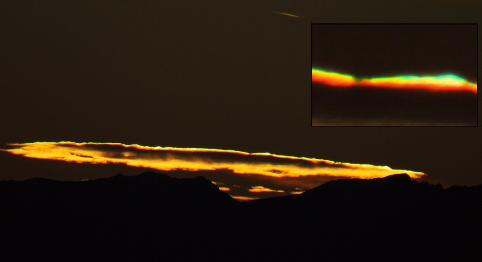
When doing a new search for similar reports I encountered an observation from by Robert Wagner, January 7th, 2008, who also recorded green cloud rims during sunset on La Palma (2136 m above sea level).

No other documented observations could be found on the internet so far.
We cannot offer a complete explanation yet. It may be that the cloud edge, when illuminated from behind, acts as a separate light source and the green flamelets are then caused by the refractive dispersion of a weak mirage effect. This is consistent with the presence of blue and green rims at the sun, which indeed have been observed in all three cases. Furthermore, all observations were carried out from high mountains, from where the true geographic horizon already lies below zero elevation, and even the ordinary elevation shift due to refraction is already pretty high due to the long light path through the atmosphere.
More ideas and reports of similar observations are welcome in any case.
Author: Claudia Hinz
—
Edit 21th March, 2017:
I would like to add a video to this article, in which I was record the green rimmed clouds on the Mt. Fichtelberg/Ore Mountains on 20-12-2016.
Gloridescent clouds

As “Gloridescence” I define colored clouds in the antisolar area, where there is no visible connection to a glory.
The first observation of colored clouds at the antisolar point was made by Stefan Rubach on Mt. Großer Arber at Jan. 26, 2007. We suspected fragments of a glory, but we were not sure.

Jan. 26, 2007: Glorydescence on Mt. Großer Arber. Photo: Stefan Rubach
On Nov. 18, 2007, I made the first observation of my own and on Mar. 1, 2010 my second observation at Mt. Wendelstein (1835m).
-

- Nov. 18, 2007-Wendelstein
-

- Nov. 18, 2007-Wendelstein
-

- Nov. 18, 2007-Wendelstein
-

- Nov. 18, 2007-Wendelstein
-

- Mar. 1, 2010-Wendelstein
At Mt. Zugspitze (2963m) I observed these colored clouds a few times and named them „gloridescent clouds“ (and so far no one ever challenged this name).


On Apr. 25, 2015 I made my first observation of „gloridescent clouds“ at Mt. Fichtelberg (1215m). Meanwhile we received more observations, one from the valley of Neckar river, one photo by Eva Beatrix Bora from Stavanger, Norway and some from an aircraft (1 – 2). From these we conclude that:
- Just as glories become more frequent with increasing observing levels (see this article), the frequency of “Gloridescence” also increases.
- At lower altitudes (i.e. in the area of low clouds), “Gloridescence” originates mainly from underneath of stratocumulus clouds.
- At higher mountains (e.g. Zugspitze, 2963m) and on airplanes, “gloridescent clouds” are more frequent and appear mainly in deeper cloud layers or single shreds of clouds.
Author: Claudia Hinz, Schwarzenberg, Germany
Frequency of glories from different observation levels
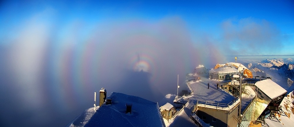
Glory and Fogbow with interferences at Mt. Zugspitze
The combination of spectre of Brocken with glory and fog bow is named after the German Brocken mountain, even though it cannot be observed there too often. My colleagues from the weather station estimated a frequency of 2 or 3 observations per year at the top of the mountain. The phenomena much more frequently observed at higher mountains.
Since there is no reliable statistics about the frequency of Glories to date, I tried to obtain some tendencies from my own observations on various mountain tops.
I observed at three different mountain tops where I worked for a longer amount of time:
- Mount Fichtelberg, Ore mountains, 1214m (similar height as Mt. Brocken)
- Mount Wendelstein, Alps, 1838m (standalone rock)
- Mount Zugspitze, Alps, 2963m (main mountain chain of the Alps)
Fichtelberg I observed most frequently in the early morning hours without interferences. On Mt. Wendelstein the Glories often long duration phenomena, sometimes very colorful with impressive interferences. On top of Mt. Zugspitze the Glory was visible at every solar altitude, in most cases long duration, with impressive interferences an colors.
I tried to capture the frequency of glory statistically. Since I could not look at the same time periods, the statistics is an approximation.
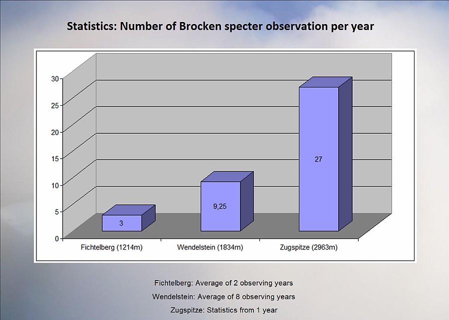
These observations lead to the following conclusions:
- The frequency of glories increases with altitude (at my observing sites the number of glories increased by a factor of three for every 1000m altitude)
- The higher the altitude of the observation point, the more impressive are the glories! With increasing altitude of the cloud, the size of the droplet in the clouds decreases and interferences become more frequent. Because the smaller and more uniform the droplet size, the more impressive becomes the glory (Simulation of Les Cowley). In the best case, the glory transforms into interferences of a cloud bow.
- The duration of the phenomenon increases with the altitude, too. If the local conditions allow observations well below the horizon, the glory is possible at every solar altitude.
-

- Fichtelberg
-

- Fichtelberg
-

- Fichtelberg
-

- Fichtelberg
-

- Fichtelberg
-

- Wendelstein
-

- Wendelstein
-

- Wendelstein
-

- Wendelstein
-

- Wendelstein
-

- Zugspitze
-

- Zugspitze
-

- Zugspitze
-

- Zugspitze
-

- Moon Glory Zugspitze
Author: Claudia Hinz, Schwarzenberg, Germany
Binary double rainbows

In past years I have done spot light rainbows when the rain was a fine mist. After seeing the results of a nice fog bow my LED flashlight made and since I had two I thought why don’t I try doing two at once. So I turned both lights on the hi-power mode which yielded a very bright beam of light and both lights were placed on fence posts 2 meters apart. I angled the lights so the beams crossed and at the point where they crossed is where I placed the camera. I took a shot was blown away by the results! There it was two full circle double rainbows crossing one another. I took quite a few shots before I was getting chill and wet. Just think if you landed on an Earth like exo-planet orbiting a binary star system and upon exiting your space craft you look up and see twin suns shining above then you hear a rumble of thunder. You retreat into your ship for shelter and later the storm moves on but its still raining but you look on the opposite side of the sky and see two double rainbows displaced a few degrees apart and the bows would cross one another. These flashlight binary double rainbows show how rainbows would look to civilizations living on Earth like Exo-planets orbiting double, triple, or even quadruple star systems. Next time I will use 3 and 4 LED flashlights. On the nights I was doing these bows the wind was blowing and I could see the primary bow in particular would move from side to side and one pic even shows that it could be twinned!!!


Author: Michael Ellestad, USA
Commonly spread Ice Wool
On February 2nd, 2016, we made an excursion to the Anna Tower together with my daughter´s form. The Anna Tower is located in the Deister hills, a small range of hills at about 20 kilometres southwest of Hanover. Its highest elevation ist Mt Bröhn near the Anna Tower with about 405 metres above sea level. We startet from the Nienstädter Pass at 277 metres above sea level. The car park there is covered with gravel and normally rather muddy, but that day it was frozen and hoar frost glittered everywhere. When we startet our excursion, the weather was bright and sunny. But as soon as we left the car park, I noticed a fibrous thing of brilliant white just beside the path which leads along the top of the range. At first sight, it looked like a sheared piece of wool from a sheep. But for me it was clear what it was: ice wool!

The first ice wool I ever found
Up to then, I knew ice wool only from descriptions, and although I had been looking for it for years everytimes there was a light frost, I never found some. And now I found it right beside the path, without having searched for it! After having given others a hint on that phenomenon and explaining it, I took some photographs and then continued my way – slowly and even slower, because there were more and more tree branches which showed ice wool. After having found 10 of these ice wool formations, I roughly counted them, but when I reached 50, I stopped counting. It made no sense, because there was too much. I found a place where at least 20 branches and twigs with ice wool laid around. Not every ice wool formation was well defined, but there were also some very bizarre ones among them!

Large accumulation of branches with ice wool
I arrived at the Anna Tower about one hour delayed. The weather was nice, but it was not really clear. There was a distinct inversion with a pronounced layer of mist, but without any mirages. I think, for this the hill is not high enough. (At really clear conditions you can see Mt Brocken in the east and the Porta Westfalica in the west from the Anna Tower).


Three weeks later, on February 27, I succeeded in finding ice wool at the Nienstädter Pass again. This time I was prepared better and brought a retro adapter to make macro photographs. Thus it was possible to take detailed pictures of the ice wool. Some parts of it had structures which reminded of chains of bacilli. Other parts just looked like shiny and transparent hair. The augmentation effect of the lens with retro adapter was not strong enough to unravel the structures here.

-

- Modified by CombineZP
-

- Modified by CombineZP
Background information:
Ice wool is a physical and biological phenomenon which mainly appears on rotten and decayed wood in deciduous forest with mixed types of trees. It forms hairy ice curls of a brilliant white which remind of candyfloss. Sometimes it looks like paintbrushs with the uppermost parts cut away, others look like wool from a sheep, others remind of minerals or lichen. And sometimes it looks just like a thrown away paper tissue and is often mixed up with this from the distance. But it has always this hairy and cristalline structure which sometimes looks like chains or if it was covered with sugar.
Ice wool is caused by the activity of funguses which decompose rotten wood. During this process, water is set free which gets out of the dead wood through capillaries and freezes at temperatures around or slightly below 0 °C, forming these hairy ice structures. This works as long as the wood itself does not freeze. Contrary to hoar frost crystals, ice wool is formed by liquid water from the wood freezing outside while the atmosphere is not involved. It is not long ago that the process could really be clarified.
Ideal conditions for the formation of ice wool are given when after a period of mild weather with (light) rain the sky clears off at night allowing frost on the ground. So, when you have to scratch the ice off your car windows, there is also a chance of encountering ice wool in the forests. It can be found from October until the beginning of March, except during very cold periods. Best places to find ice wool are under oak and beech trees and maybe also under some larches. Other conifers are not suitable.
But you also need some good luck when looking for ice wool, just as it normally is not wide spread. Similar to the appearing of mushrooms and toadstools, there seem to be good and bad years. Even if the conditions may apparently be perfect, you will not automatically find ice wool. Locations also seem to play an important role as I could see for myself a short time ago. While ice wool was rather abundant up there along the path on the top of the range, I could not find any of it in the Deister forest near my home, although the tree population there is not very different from that at the Nienstädter Pass. Also here lots of branches and twigs in all stages of rotting are lying around, but there is not a single trace of ice wool to be found.
Author: Reinhard Nitze, Barsinghausen, Germany
Fogbows in Tenerife


11th of May, 2016 Roberto Porto observed in the Teide National Park (Tenerife, Spain) wunderful fogbows in top of a deeper cloud layer. The moderate climate of Tenerife is controlled to a great extent by the tradewinds, whose humidity is condensed principally over the north and northeast of the island, creating cloud banks that range between 600 and 1,800 metres in height. If moves out of the cloud layer as far as you can see the sun, one has with the sun behind the best observing conditions for a fog bow.
As the name might suggest, a fogbow is the name given to a phenomenon created by the same process of refraction and reflection that creates rainbows, but formed instead by the water droplets in fog, mist or cloud, rather than raindrops.
The timelapse video show 3 different fogbows in the sea of clouds of Volcano Teide. The sun low in the horizon produced the beautiful fogbows.
Photo data: Nikon D5300 and Nikon D90 with Nikkor fish eye 10,5 f:2,8 and tamrom 18-200mm
Unpaired reflection rainbow

Webcam Cully at Lake Geneva on May 25th, 2016. By courtesy of foto-webcam.de
The ever growing number of webcams is worth to be checked for both common and rare atmospheric optics phenomena, e.g., like in the case of these twinned rainbow, rainbow at high and low sun (1–2–3–4), red rainbows (1–2–3–4) or moonbows (1–2–3–4).
The Swiss webcam located in Cully at the North shore of Lake Geneva (Lac Leman) has shown a most unusual pair of images within 10 minutes on May 25th, 2016. Starting from the last image (see top right) taken at 20.40 Central European Daylight Saving Time we see fragments of a normal primary rainbow before sunset, which happened at 21.08 CE-DST. From its beginnings on the lake’s surface it is immediately slanted toward the antisolar azimuth in the East.
However, the image taken 10 minutes earlier (see top left), at 20.30 CE-DST, shows not just a weaker bow, but also, that it starts at the lake’s surface slanted toward the West, i.e. away from the antisolar azimuth!
This strange sight is an isolated reflection rainbow, which is also centered on the antisolar point, but, at the solar elevation of 4.9°, somewhat larger than a semicircle, thus explaining the odd slant at its foot. The missing of a normal rainbow (except of, may be, a slight trace) in this image can be explained by a very patchy type of rainfall or shadowing of the corresponding regions. Additionally, the images show hints of a reflected rainbow and a reflected reflection rainbow, respectively, projected on to the lake’s surface.
Authors: Elmar Schmidt and Claudia Hinz
Twinned rainbow from Russia

Twinned rainbow in Siberia, Russia in Original and with unsharp mask. Photo: Ivanna Dark
In June 21, 2016 Ivanna Dark observed Yurga, Kemerovo region in Western Siberia, Russia an clear twinned rainbow: “At 19:45 local time (UTC + 7) began to fall to the ground a few large drops of very weak rain. I decided to look at the rainbow, because I know that it will appear in the presence of the sun. Imagine my surprise when I saw that the rainbow has a certain strangeness. It was not a Supernumerary Rainbows, but seen clearly, that the top part split into equal pieces. Later I found out the name of this phenomenon – Twinned Rainbow. Although the rainbow was very faint and lasted about two minutes, it did not stop to notice the duality of top.”

